Showing posts with label Metro. Show all posts

Thursday, January 21, 2010

Local Governments Seek to Transform Wheaton Downtown

5 comments
Ten sites in Wheaton are up for grabs now that Montgomery County, the Maryland-National Capital Park and Planning Commission and Metro, a.k.a. the "Public Team" which individually own the properties, has released a request for qualifications for a public-private partnership to develop and transform any one or combination of the ten spaces in the Wheaton Central Business District. The plots total 11.7 acres, all within 1,200 feet of the Wheaton Metro station.

The three land owners are working together to create a constellation of new development to build a "high quality...vibrant community" with increased density that will transform the Wheaton CBD. Projects should be transit oriented, mixed-use developments that create active open space and promote pedestrian-friendly transit. The two-tier process will first rate the developers' "creative vision" and ability, saving project specifics for the second stage of application process.

Housing options should include moderate-income, workforce housing and live-work units such as art studios. The ten lots include both contiguous and stand alone plots. Depending on the owner, the property may be either leased or purchased. Expect a localized price spike, as developers may combine other parcels in their proposals by showing they will have the ability to control adjacent parcels for future development.

The properties are listed in groups, though each can be developed individually. Group A includes a Parking Lot on Price Avenue, a garage on Fern Street and Veterans' Park on Reedie Drive, a total of 2.62 acres. In the case of Veterans' Park, a developer would be required to "identify a replacement location for the park that enhances its impact upon the public realm."

Group B holds the bulk of the space with 8.02 acres, including three Montgomery County-owned parking lots, a Montgomery County Regional Service Center on Reedie Drive and two Metro properties. Concept plans for the Regional Service Center should address replacement locations for the services normally provided by the site.

The Metro offerings include a bus bay on Georgia Avenue and a 1.94-acre garage on Veirs Mill Road. Metro requires any developer with plans for the bus bay to develop an interim site prior to construction and an alternate permanent location for the facility in close proximity. Metro is not seeking replacement of the garage, which connects via a pedestrian bridge to the Westfield Wheaton Mall. However, any developer seeking to "better integrate these facilities with transit oriented development" would need to replace the "existing uses at appropriate levels of functionality," with replacement costs borne by the developer.

That leaves the sole member of Group C, a 1.06 acre Montgomery County-owned parking lot on Blueridge Ave. Despite the tie to Metro, the team is requiring that applicants replace all five parking lots with "appropriate levels of replacement parking/capacity."

Submissions are due March 19th, a pre-submission conference with site tour will be held February 2nd. A short-list of candidates will be released on April 14th, at which time the second phase information will be released.

Wheaton real estate and development news

Friday, September 18, 2009

Metro Breaks Ground in Ward 8 Bus Garage

1 comments
On Wednesday, Metro ceremoniously broke ground on a new $95 million bus garage in Southwest DC. The garage will replace the seldom-missed bus depot near the Nationals' ballpark, sold to Akridge and Monument Realty in 2008 and demolished to make way for a multi-use (but unbuilt) project. Despite the formal groundbreaking, Metro still has not selected a contractor, nor provided a timeline therefore.

Metro paid $6.45 million for the former DC Village, a homeless shelter site, which will house up to 114 buses serving the greater DC area, with the potential to expand service for up to 250 buses. The agency anticipates the new bus facility will be open by 2012.

Wednesday, June 17, 2009

Purple Line Vote Affirms Maryland "Rail on the Trail"

6 comments
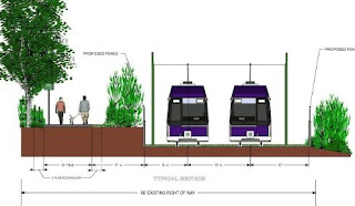
The metro area's arbiters of all things transit, the National Capital Transportation Planning Board (NCTPB), today voted unanimously to endorse light-rail as the preferred mode of transport for the 16-mile Purple Line project between Bethesda and New Carrollton. The light-rail option, which has already received the support of both the Montgomery and Prince George's County Executives and County Councils, along with the Coalition for Smart Growth and the Washington Area Bicyclist Association, has faced a long string of criticisms from Bethesda/Chevy Chase area residents who fear that the project will render their three-mile spur of the Capital Crescent Trail system both physically and environmentally unsound.

Trail supporters lobbed various critiques at the Purple Line prior to the vote, including claims that it would make the area unsafe for schoolchildren, lead to the deforestation of Bethesda’s last remaining green space and the system will amount to little more than a “two billion dollar trolley line.” Others reasoned that the planned location of the Purple Line’s Bethesda depot at Woodmont East is too far away from the Metro, the National Institutes of Health and the soon-to-be relocated Walter Reed Army Medical Center to have any impact on traffic in the area. Anti-light rail advocates instead proffered that the NCTPB should endorse rapid bus service from Bethesda to Silver Spring as the Purple Line’s preferred mode of transport.

“Some of my constituents in Chevy Chase will advocate…bus rapid transit on Jones Bridge Road - [an alternative that] is not supported by the residents of Jones Bridge Road,” said Montgomery County Councilmember and Purple Line Now! founder, George Leventhal. “The difficulty that we have in proposing an alternative that is preferred by both counties, and that is likely to be endorsed imminently by Governor O’Malley, is that anywhere you try to move this transitway, you encounter other problems…This alternative, which is included in our master plan and has been endorsed by both counties, is indeed the right transitway for our congested, urban, inside-the-Beltway corridor.”

Leventhal went onto to point out that his county initially acquired the Capital Crescent Trail for the express purpose of having both a “recreational hiker/biker trail” and future transit line at the same site.

“There would not be a trail today had not Montgomery County, back in 1990, acquired that right-of-way for the purpose of building what is now called the Purple Line,” he said.

Though some area organizations- most notably the Bethesda Civic Coalition's Save the Trail campaign, which collected some 18,000 signatures in support of their cause – opposed the plan, the majority of testimony submitted to the NCTPB was overwhelmingly favorable. With an estimated daily ridership of between 42,000 and 46,000, many believe that the “Rail on the Trail” will provide a crucial east-west link between Montgomery and Prince George’s Counties, resulting in an economic boom for outlying communities and a more efficient Metro system. Even frequent trail users spoke out in support of the plan, illustrating just how multifaceted the Purple Line debate had become.

“The media, unfortunately, portrays the issue of the Purple Line as black and white. You either support the Capital Crescent Trail or you support the Purple Line, but not both. That’s not the case with WABA,” said the cyclist organization's Executive Director, Eric Gilliand. “When finally constructed, the Purple Line will include a direct bike-ped link with the Silver Spring Transit Center, where it will eventually link with the Metropolitan Branch Trail coming out of DC. This is a critical bike/pedestrian transit project that must move forward.”

With NCTPB approval now in hand, the Purple Line’s next stop is with Maryland governor Martin O’Malley, who is expected to endorse the light-rail option and announce a timetable for construction by year’s end. In the meantime, NIMBYs on the other side of the Potomac can get ready for another Metro-centric debate now that plans for a proposed Silver Line, running from downtown Washington to Dulles Airport, are being openly discussed.

Thursday, March 12, 2009

Waterfront Station 1 Tops Out in Southwest

0 comments
Waterfront Station officially topped out today, and while that alone may be cause for celebration, backers must be more pleased that the office building is entirely leased. Once completed, the Southwest Washington, DC development - a joint venture between Forest City Washington, Vornado/Charles E. Smith and Bresler and Reiner, Inc. - will add 2.5 million square feet of office, residential and retail space to the former site of the Waterfront Mall at 4th and M Streets, SW.

District authorities, in particular, have reason to commemorate the project's construction milestone. City agencies, including the Office of the Chief Financial Officer, Office of Planning, District Department of Transportation and Department of Consumer and Regulatory Affairs, have already leased the entire 628,000 square feet of phase one’s Shalom Baranes-designed dual office buildings and are currently scheduled to move in once construction ends in March of 2010. The towers, which abut the Waterfront/SEU Metro station, will also include new space for the present Safeway, CVS and Bank of America locations on site, as well as an additional 85,000 square feet for restaurants and “neighborhood service-related” retail. Both buildings are aiming for a LEED silver certification. Clark Construction is currently serving as general contractor on the project.

Mayor Adrian Fenty, on hand to officiate the proceedings, also took time to wax nostalgic about his history with the project. “I’ve been the mayor for twenty-six months and ten days and I can tell you that this has been a priority of our administration for that entire time," he said. "I was on the City Council before that and I followed, as an interested appropriator, all of the discussions around Waterside Mall."

Meanwhile, Ward 6 Councilman Tommy Wells and Councilmember-at-Large Kwame Brown applauded the project for revitalizing a long-neglected Southwest site and proceeding as planned, despite the current state of the real estate market.

“I believe the financing [for this project] was closed on the day the Dow dropped 700 points [on September 29th, 2008]. This team saw it through,” said Wells. “You may see other cranes that have stopped working, other places that they stopped digging, but these guys are work because of this great development team.”

In between accolades, not much mention was a made of the development’s projected phase two component, which is intended to include nearly 1,000 residential units, along with more retail and office space, to fill Waterfront Station’s eventual 2.5 million square footprint. The current timeline calls for design work on the next phase of development to begin this coming May and Deborah Ratner Salzberg, President of Forest City Washington, Inc., was optimistic that the project will a be success based on its convenient location and the inroads made so far.

“People are going to come up from this Metro, they’re going to head home, they’re going head to school, they’re going to go to work and they’re going to shop. Waterfront Station will be an active retail hub,” said Salzberg.

Washington DC real estate development news
Wednesday, February 11, 2009

Alexandria Eyes New Metro for Potomac Yard

2 comments
Just in time to reap some juicy stimulus dollars, the City of Alexandria is now exploring an additional front in their ongoing plans for the redevelopment of the city's former industrial sector, Potomac Yard. This month, the Alexandria City Council formally established the Metrorail Station Feasibility Work Group with the express purpose of "assess[ing] the technical and financial analyses required for a potential new Metrorail Station in Potomac Yard."

Both the Planning Commission and City Council expressed interest in a possible Metro expansion into Potomac Yard back in May 2008, when they undertook a "preliminary analysis of concept." That study resulted in a Washington Metro Area Transit Authority estimate that priced the project at $125 to $150 million with an operating cost of roughly $1 million per year. The hope is that a Metro outlet in the currently barren Potomac Yard quadrant of Alexandria will kick start – or, at the very least, accelerate - the redevelopment effort that aims to add 1 million square feet of office space, 750,000 square feet of retail, 2500 residential units and an undetermined number of hotel rooms to Northern Virginia.

Members of the Work Group include William Euille and Timothy Lovain of the City Council; Eric Wagner of the Planning Commission; Noah Teates of the Potomac Yard Planning Advisory Group; and Jennifer Mitchell of the Transportation Commission. The Work Group will hold its first public meeting on Thursday, February 17th. The meeting will be held at the Sister Cities Conference Room at 7 PM.

Though the House and Senate versions of the stimulus package have yet to be reconciled with one another, both versions contain large - though differing - amounts for infrastructure spending. Once the money is routed to the State Legislature (and possibly WMATA), these seems like precisely the type of project they'd be willing to explore. Barring, of course, that it doesn't cut into the caviar fund.

Wednesday, October 22, 2008

St. Elizabeths Plan Envisions Massive Redevelopment

3 comments
The District announced a new plan today to kickstart redevelopment of the old St. Elizabeths mental institution in Ward 8. If approved by the District Counsel, the series of projects will beef up one of DC's poorest neighborhoods with nearly 3 million square feet of mixed-use development. Mayor Adrian Fenty, Congresswoman Eleanor Holmes Norton, and Office of Planning Director Harriet Tregoning were on hand today to announce the release of the St. Elizabeths East Redevelopment Framework Plan, which recommends transforming the hospital’s eastern, District-owned flank into five neighborhoods, "each with their own character," and pushes for the Department of Homeland Security's (DHS) proposed relocation to federally-controlled St. Elizabeths West. The government transferred ownership of the eastern portion to the District in 1987, while retaining the western campus for its own use.

The Plan is sprawling in its scope – the size of the District-owned eastern half alone measures in at 173 acres. Together, construction on the two campuses - separated only by Martin Luther King, Jr. Avenue, SE - would be second only to the revitalization efforts underway on the Southeast Waterfront in terms of size and scope.

“I think what we have proposed…will not only benefit the people who live in Ward 8 and east of the river, but, just as importantly, the entire city,” said Fenty.

Redevelopment at St. Elizabeths East would create up to 2 million square feet of new mixed-use projects and 750,000 s.f. of renovated historic space. The proposed neighborhoods (pictured, below) are being broken down into the North Campus, Maple Campus, Town Square, CT Village and Metro Station; each would feature a distinct blend of commercial, retail and/or residential space, in addition to “civic and community” areas. The northern portion of the site has been reserved for DHS office space and parking – a move made to sweeten the deal for the Feds, no doubt (more on that in a bit). Meanwhile, the historic St. Elizabeths Hospital, its new 435,000-square foot secondary building and John Howard Cemetery on the grounds would be retained.

The Plan also includes provisos for a cohesive link to the two local Metro stations and MLK corridor, where the City is betting on seeing an influx of retailer and developer interest.

On the western campus, DHS’ proposed relocation would include the construction of new, secure headquarters meant to accommodate roughly 14,000 government employees. If and when the project moves forward, it would mark the first time the federal government has ever crossed the Anacostia River, according to Congresswoman Norton. DHS currently lacks a consolidated headquarters, with offices at different locations throughout the city.

The impact of such large workforce on the environment, Metro capability and local traffic is still being evaluated, while the inclusion of the site in the proposed southeast street car system is still a possibility.

The District will submit the Plan to the City Council next month with a decision to follow in December. A Request for Proposals regarding the DHS parking lots and offices is planned for December as well, the District hopes to break ground on that phase of the project in the first half of 2009. Norton described development as moving along an “unusually fast track.”

The Plan is the product of more than 5 years of parallel development by the General Services Administration (GSA) and the District. According to Norton, it's has been included in the Bush administration's budget for three straight years, but has only been able to move forward, ironically enough, since the Democrats came to power in Congress. The challenge now lies in convincing that same body that moving DHS to another, federally-owned piece of property in Southeast would be beneficial and, most importantly, cheap. It would appear that the future of both East and West hinges on a decision by the federal government; if DHS settles on another location or Congress blocks the site, it could be a deal breaker for both halves of St. Elizabeths.

“There will be great potential here if we continue to do it right. The city and the government will work closely together, as we have on projects in the past,” said Norton.

A budget for the project is forthcoming, and Norton will be holding a town hall meeting tonight from 5:30 - 7:30 PM at the UPO /Petey Greene Community Service Center (2907 MLK Jr. Ave SE) to disclose more details and listen to questions from the public. Another community meeting will be held at St. Elizabeths on October 28th.

Friday, August 29, 2008

Rosslyn's Severe Case of Tower Envy

2 comments
The Rosslyn skyline will be changing significantly in the coming years as two new mixed-used projects shoot skyward. Interestingly, both have at one time hyped themselves as the metro area's tallest developments, JBG's Central Place and Monday Properties' 1812 North Moore Street have both been cleared to exceed the 300 foot height limit usually imposed by Arlington County, both will be runners-up for the region's tallest after the Washington Monument. There's just one problem: with the dual towers of Central Place already under construction and North Moore breaking ground in October, neither side wants to relinquish their bragging rights to the title of tallest.

This has been a long time coming for 1812 North Moore. Now-defunct Westfield Realty sold the $31.5 million parcel to Monday Properties in 2006 after the former’s long-gestating bid to revamp the site went nowhere (not so) fast. Monday, however, have had much more success with their attempts to put the project into turnaround. Their Davis Carter Scott-designed tower boasts 600,000 square feet of commercial office space, 12,000 square feet for retail and a Metro terminal attached to the facility. Additionally, they’re on track to become the first LEED Platinum-certified building in the State of Virginia – a measure that has earned them accolades from the Rosslyn Renaissance (RR) Urban Design Committee (UDC) and the Radnor/Fort Myer Heights Civic Association (RAFOM) and will make them one of the most energy efficient buildings in the country.

But once the plans went public, it wasn't long before creative math came into play. Originally, both Central Place and North Moore were billing themselves with a height of 470 feet – including sea level. Eventually, the dueling parties seemed to realize that adding a hundred plus feet of land elevation to a building’s proposed height was tad on the disingenuous side. (After all, Denver’s Republic Plaza would be the tallest building in the world if it included the city’s 5,280 foot elevation in its’ official measurements.) And that’s where things get confusing.

Currently, Monday Properties says that their proposed 30-story complex on North Moore will come in at 390 feet – and that the Central Place will top out a whopping 60 feet below them. But in December of last year, the Arlington County Planning Commission made Monday shave a story off their blueprints, so as not to obstruct the view from Central Place’s observation deck – the one that was supposed to look down on North Moore. (Further complicating matters is the fact The Washington Post reported North Moore’s post-Planning Board height at a diminutive 370 feet.)

Unsurprisingly, JBG is singing a different tune. Their website states that the taller of their two towers will measure in at 31-stories - 390 feet. According to Thomas Miller of the Arlington County Planning Division – the county body with access to blueprints to both sites - the he-said she-said bit is all for naught.

“Both buildings are 390 feet,” he said Thursday afternoon, “Although, the highest [North Moore] offices actually fall below the observation deck level [of Central Place].”


He also confirmed that the two buildings only have a 3 foot difference in base elevation, but did not specify which. So depending on your point of the view (or the address on your lease), the second highest point in the Washington area is soon to be either Central Place’s glass-enclosed 31st floor tourist draw or the luminescent glass pyramid that will cap North Moore.

All in all, this only serves as a lesson in the strategic power of PR. Both buildings are to offer hundreds of thousands of feet office and retail space that represent a dramatic expansion of Rosslyn’s commercial prospects. Given that the two sites are separated by roughly only 200 yards, the competition for luring prominent DC businesses into these new NoVa nerve centers was bound to be stiff. While 1812 North Moore has yet to commit to a delivery date, Central Place is scheduled to be completed in 2011. Only then will we see who really comes out on top.

Wednesday, June 18, 2008

Common Commotion in Rosslyn

0 comments
Rosslyn's it developer, JBG, is having quite a week. First they prep for demolition to make way for the area's new tallest building, and then they receive approval from the Arlington County Board for Rosslyn Commons, a mixed-use, transit-oriented development on Clarendon Boulevard. This new development will bring 454 apartments, 25 four-story townhouses, 12,000 s.f. of ground floor retail, 31,913 s.f. of open space, and four levels of underground parking to a 2.8-acre site three blocks from the Rosslyn Metro; quite an addition for an area that has until recently been office oriented and drained of humanity after rush hour.

Replacing the current 84-unit brick garden apartments on site, the new apartments, designed by Bethesda-based firm Architects Collaborative, will be divided among two, L-shaped towers. The first tower, bounded by Clarendon Boulevard, 17th Street North, and N. Oak Street, will offer 262 units and stand thirteen stories high, gradually lowering to eleven stories along Clarendon Blvd. All fifty-four units of affordable housing will be located in this building. The second tower will climb to twelve stories on the corner of Clarendon Blvd. and N. Ode St. and offer 192 units and retail space.

The color pallet for both buildings is planned as an attention grabbing combination of “tan-brown, reddish brown and pink-brown brick with gray-blue to gray-green metal frames.” Affordable units will include 26 two-bedroom apartments renting for $1,329, 22 one-bedroom units renting for $1,107 and six three-bedroom apartments to rent for $1,535.

Mixing up the urban vibe will be twenty-five town homes on site, separated into two rows; one will face an interior courtyard, the other will face 16th Road North.

The site scores high in the green department – both apartment buildings will be LEED certified, and the town homes will comply with the county's Green Home Choice Program. Commons residents will receive the uncommon bonus of SmarTrip Fare Cards for the Metro system.


DCmud - The Urban Real Estate Digest of Washington DC Copyright © 2008 Black Brown Pop Template by Ipiet's Blogger Template