Showing posts with label Office of Planning. Show all posts

Friday, October 05, 2012

Populist Real Estate: Crowdfunding and Planning in DC

0 comments
District Architecture Center, photo courtesy AIA, DC chapter

With DC growing by nearly 1,100 residents per month, according to the Office of Planning (OP), some residents might feel swept up in change.  But one OP initiative aims to frame DC residents as more than just "passive recipients" of planning and urban development.  The city is not alone; several groups - even a young DC company - are headed in that direction.

A "Citizen Planner Forum" was held Thursday night at the District Architecture Center, which opened last year at 421 7th St. NW.  The event marked the culmination in a months-long joint initiative of the DC Office of Planning (OP) and the Washington, DC chapter of the American Institute of Architects (AIA) to get input on place-making from people other than experts.

Real Estate and Crowdfunding

Before: Fundrise 1351 H St. NE, image courtesy Fundrise
Another example of projects built on the concept of collaborating with neighbors on development: Fundrise.  The new project in DC is based on using crowd-funding to buy properties, and the message "build the city you want to live in." Through Fundrise, the entity 1351 H Street has already gotten $215,000 in local investments to renovate a property on H Street, according to its web site.  The architect for the renovation is Michael Francis at Queue, LLC.

Daniel Miller is a principal at WestMill Capital Partners real estate development company and co-founder of Fundrise.  He spoke to the group Thursday.  Miller said Fundrise, which Launched just six weeks ago, is based on the concept that any resident of DC or Virginia can buy a $100 stake in a property and help jump-start a small business.  Miller said investors could also get returns.

Fundrise follows on the heels of WestMill's web site Popularise, a crowd-sourcing web site that allows property owners to survey citizens about what they want a property to become.  WestMill has used it to crowdsource ideas for its own property, but other real estate groups have used Popularise too.

Residents Re-framing Development Discourse

Offering another example of the way residents DC are already re-framing the discourse, Anacostia resident Veronica Davis talked about her experience as a co-founder of "Black Women Bike DC"
Davis noted that growth can trigger tensions surrounding race and fears of being "priced out". An unexpected symbol of that tension, panelists said: bike lanes.

After: 1351 H St. NE.  Rendering courtesy Fundrise
Davis explained that for some residents of DC, bike lanes seem like harbingers of change, even omens of higher rent.  "We founded Black Women Bike to say – we do bike," Davis told the group. "And we needed infrastructure. Part of that is being visible."
 
That kind of citizen action is what the OP wants to encourage.  The aim is to "work together and not just talk at each other," OP director Harriet Tregoning told DCMud. "Our neighborhoods are going to be better-functioning if people feel they have a stake in their neighborhoods."

Carolyn Sponza of AIA DC, also an architect at Gensler, said the main themes that emerged from four earlier focus groups were: a desire for more education about the way planning works, an idea for a planning network that would connect neighbors across wards,  the need for public spaces and "somewhere to sit", and a need for new modes of participation in planning. 

Washington D.C. real estate development news

Thursday, August 16, 2012

DIY City Planning: OP and AIA DC Launch Citizen Focus Groups

4 comments
Ever been to a planning meeting?  Fuzzy on development zoning and permitting, but still have ideas about D.C. development or what exactly makes a great neighborhood?  The D.C. Office of Planning (OP) - the municipal authority charged with shaping the District's urban landscape - still cares about what residents like you have to say.  That's the message the office is sending with a new series of focus groups.

The District Architecture Center, Image courtesy AIA


In collaboration with the American Institute of Architects (AIA) DC Advocacy Committee, the OP, under the direction of Planning Director Harriet Tregoning, has launched a series of focus groups to get a picture of resident thoughts on place-making and everything from transportation to use of public space. Two focus groups, of two hours each, have already met and two are coming up.

The focus groups signal a real effort in the planning department to look beyond planning meetings and foster citizen agency.

The deadline to join the groups was August 8th, and OP officials say there was an overwhelming interest to join: the office received hundreds of applications and selected participants who had been both more engaged and less engaged in official city planning processes.

"We have these very official – and some might say officious – ways of doing business and engaging people," Tregoning said. She noted that development and planning initiatives go through a complex approval process some residents might find distancing.  But, she said, many are already working informally - both outside city hall and with the city - to improve their neighborhoods. Tregoning points to a recent project under the city's Temporary Urbanism Initiative in which, with grant funding from ArtPlace, citizens painted a plaza with cafe tables and imagined structures to show what the plaza would be like if it were a place for people and not cars. 

"People have a lot of energy around this but there is not necessarily a place for it to go, and how can we harness it for the betterment of the city and for the neighborhood?" Tregoning asked.

The idea for the forums emerged from joint meetings between OP officials and the new D.C. advocacy committee of the AIA.  Carolyn Sponza is the enthusiastic head of the committee and has been a key force behind spearheading the effort.  She said the two groups realized there was a real "synergy" between AIA D.C.'s advocacy committee's goal to engage broad community issues larger than architecture, and the OP's "Citizen Planner Initiative." 

An architect at Gensler and AIA volunteer, Sponza said that residents have raised a diverse range of issues so far.  She said two main themes have been urban mobility and connectivity. "There were a lot of things about making connections, like the 'I can't get there from here syndrome,'" Sponza told DCMud.  She said people were also interested in growing connections, both between neighborhoods and between citizen organizations and non-profit planning and architecture services.

Tregoning said the forums are meant to explore ways to reach people and engage people more informally and more frequently on different kinds of issues. "There is just a ton of interest in what makes good neighborhoods and good places and a lot of people in the city have this deep curiosity in good cities," Tregoning added. "We were interested in ways to try to satisfy that curiosity and at the same time try a better constituency for better planned neighborhoods and better citizen engagement."

Tregoning pointed to many possible outcomes that could emerge from the focus groups:
  • A "Development 101" module about how development happens in the city and how residents can have influence in the process.
  • Further engagement of citizens around traffic and development and aspects of "the built environment that lead to more trips by car or fewer trips by car."
  • Efforts in particular neighborhoods to clean up trash, get more retail, or build facilities from public trash cans to parking.
  • DIY projects
  • New ways people can participate in planning.  Most avenues for citizen input in planning are geared toward in-person meetings.  Possible new avenues might use technology to include people to engage remotely.
  • Walking tours in areas that citizens nominate geared toward fostering dialogue surrounding the question: "what makes a great place?" 
One of the explicit objectives, Tregoning said, "is to have citizens not be the passive recipients of the city's planning but figuring out ways that they can be more involved – not just as commenters in the planning project – but in thinking about what they can do to make their neighborhoods better."

The AIA DC advocacy committee will present an overview of the meetings on October 4th at the new District Architecture Center at 421 7th Street NW, in DC's Penn Quarter neighborhood, from 6:30 to 8:00 p.m.  The street-level space, also home to the Washington Architecture Foundation, was designed by Washington firm Hickok Cole Architects.  The center hosts events and exhibits aimed at engaging the public and professionals in architecture.

Wednesday, January 25, 2012

Streetcar Plan To Boost District Real Estate Values by $8 Billion, District's Chief Planner Says

9 comments
The District's ambitious plan to restart its streetcar network will cost $1.5 billion -- but could pay for itself more than fivefold with increased property values, more jobs and development along the 37 miles of planned streetcar lines, says Harriet Tregoning, the District's chief planning officer.

Tregoning unveiled the Streetcar Land Use Study and her office's number crunching session today at a smart-growth planning session at the National Building Museum. "It's really our transportation infrastructure that shapes our development," said Tregoning, noting that the District has earmarked $100 million in capital funding for the development and building of the eight-line streetcar expansion. Already the District has two lines under construction, one in Anacostia and the other on H Street NE, where more than two miles of tracks have been laid as part of a Great Streets revitalization. The District recently agreed to expand service over the H Street "Hopscotch" Bridge to connect the streetcar system with Union Station and to buy two more cars in addition to the three in storage in Greenbelt. Both lines are expected to begin limited service starting in mid-2013 with some on-rail non-revenue testing of the Skoda-Inekon-built cars beginning this year, Tregoning said.

While much of the grunt-work and operational details are being handled by the District Department of Transportation, its been up to the Office of Planning to detail the 30,000-foot view of the impact to the city as a whole, if the District can return a city-wide network of streetcars, similar to what existed for nearly 100 years up until January 1962, when the last streetcar rolled on a revenue run.

The Office of Planning's study showed that the current $100 billion values of District properties would increase by as much as $ 5 billion to $7 billion over ten years as the plan is completed and would attract investment of $5 billion to $8 billion during the same period. That might allow the District to sell $600 million to $900 million in bonds paid for the by the new revenue, the study claims.

"The streetcar's visibility and permanence will attract private real estate investment," she said, echoing a line long argued by streetcar proponents. "You don't have to worry about the route changing like you do with buses," Tregoning said in a pitch to potential real estate investors in the 100-person audience. "Please look at these corridors for your strategic acquisitions."

While drilling deep into streetcar proponent's talking points, including improving access to schools, expanding an already growing "creative class" and reviving historic neighborhoods, Tregoning poured some cold water on calls for Bus Rapid Transit (BRT), which would be cheaper and faster to get into service, saying they won't get the same bang-for-the-buck as streetcars. "BRT does not attract the same level of investment," she said.

Tregoning said that the Office of Planning estimated that the streetcar lines would add 5,000 to 12,000 additional households over ten years, above the increases already projected. That in turn would spur a further burst of retail, as 1,000 households typically support an expansion of 30,000 to 50,000 square-feet of shopping, equal to a large supermarket.

Tregoning however wouldn't answer questions on whether the ridership projections would be enough to pay for the operating costs of the system, or where the financing of the remaining $900 million-plus estimated to fully build out the system would come from. The federal government is always an option, but the study notes typically that the federal government funds only up to 50 percent of the project's cost and can add delays while the community waits for the feds to decide.

The District, according to the study, is counting on increased revenue from real estate development along the streetcar corridors to help finance future construction of the system. "We want to be able to finance the whole system," Tregoning said. That may take the help of the real estate development industry, which, she said, historically supported mass-transit systems as part of building new communities. "We are going to need private partners as well as public."

Washington D.C. real estate redevelopment news

Thursday, July 21, 2011

Ciao Bella?

9 comments
Valor Development is moving forward with its current vision to turn the former Italian Embassy at 2700 16th St., NW into a residential complex - known as "Il Palazzo" - and will visit the Historic Preservation Review Board (HPRB) next week for design approval. Valor has submitted design schematics for the preservation of the existing 3-story limestone building and the addition of two towers (5 and 8-stories tall), time will tell if the concepts by Trout Design Studio will sink or swim with the HPRB. Representing Trout Design will be principal Michael Beidler, along with architect Patrick Cook, and a few others from the small, local firm, which declined to divulge details in advance of the upcoming meeting. Following the HPRB trip will be a visit to the Zoning Commission for consolidated PUD and map amendment approval, on September 8th. The property is split-zoned, and Valor seeks to establish a uniform zone for the site (R-5-D), allowing a "shift of density that would otherwise be permitted on the eastern portion... to the western portion" as stated in the pre-hearing submission, lodged with the Zoning Commission in May. The goal of the rezone request is to "focus all additional density and height at the rear of the property." The Office of Planning concluded in April that the proposal for the redevelopment was "not inconsistent with the Comprehensive Plan" and waved Valor forward, with stated approval of the project's "special value" including "preservation of a historic resource" and five 2-bedroom affordable units (80% AMI). First conceptualized as a condo redevelopment in 2004 by previous owner Spaulding & Slye, Colliers and Castleton Holdings, HPRB deemed the site a landmark in 2006, just as construction was about to begin, a move which halted the developer's plans. Lender O’Connor North American Property Partners LP foreclosed on the property the following year. Valor Development purchased the site in 2008 for $6.5 million, and had hoped to have construction underway - partnering with Potomac Construction Group - this summer, however, Valor has also hit a few snags along the way. Valor and Trout Design visited the HPRB in November of 2010, then again in January of this year, with a plan to redevelop the property as a "luxury condominium," which has been revised over the past 6 months into 110 to 135 residential units with the majority (56) to be one-bedroom units, and 30 to be 2-bedroom/2-bath. The breakdown of the remaining units is undetermined, but the largest will be a 3 bed/2.5 bath configuration. The residential addition on the western side of the 42,500 s.f. property will now top out at 8 stories (previously 9) and will not rise over 90'; the floor area ratio (FAR) will be 2.8 with 122,428 s.f., with a lot occupancy of 58% allowing for a "considerable amount of landscaping" and a rear yard (80' in depth). The amount of below grade parking is yet to be determined, but will be between 60 and 90 spaces.Phase I will entail the "renovation and conversion of the existing Italian Embassy," including restoration of the landmark's façade, as well as preservation of notable, existing shared spaces within the once dapper host to embassy functions, including the ballroom, library and dining room. The embassy, built in 1925, was designed by New York architecture firm Warren and Wetmore, on land owned by Mary Foote Henderson, who spent part of the family fortune, made from "worthless bonds," on her impassioned goal to transform 16th Street, which included the creation of Meridian Hill Park. Valor could not be reached for comment, however stated in the PUD application an intent to break ground next spring, with construction expected to take 18 months. 

Washington D.C. real estate development news

Friday, June 10, 2011

Union Station North, New Zone to Accommodate Billion-Dollar Burnham Place Project

2 comments
Map: Burhnham Place, Lisa Steen of Akridge talks about redevelopment of Union Station
After 18 months of efforts by the DC Office of Planning (OP) to establish appropriate specifics, the DC Zoning Commission (ZC) approved OP's creation of a new zone - Union Station North (USN) - which will supersede an area zoned for industrial and light manufacturing use in the City's Comprehensive Plan. The USN Zone was created to allow developer Akridge's mixed-use planned development project, Burnham Place, designed by DC-based architect Shalom Baranes Associates, to be built above the Amtrak rail yard located immediately north of Union Station. Burnham Place, estimated early on to cost $1 billion, has been in the works since Akridge bought the air rights above the railyard from the General Services Administration (GSA) for $10 million in November of 2006, a notable transaction due to price and precedent - the deal became the first transfer of air rights from the federal government to a private buyer. The 14-acre, air-rights property will be developed into 3 million s.f. of commercial, retail, residential and hotel space. The new USN Zone District will allow Akridge to build up 90 to 130 feet above the H Street Bridge, as the bridge is technically the ground floor of the property. 
Union Station, Burnham Place, Shalom Baranes architects, Akridge, GSA, Federal Railroad Administration


According to Lisa Steen, Vice President of Marketing at Akridge, building heights will be gradual, starting 300' away from Union Station at 90', then rising to 110' and finally 130'. In this way, "The view of Union Station will not be compromised," says Steen, adding, "and the view from the buildings could be fabulous." The ZC Order was approved unanimously in April, and has allowed Akridge to move forward with design specifics, now that allotted heights for residential towers has been established. The decision to create a new zone also ensures that the ZC will have the authority to review and approve any development at the site. Furthermore, the Order allows Akridge to create a unique, and dense, transit-oriented development that utilizes project neighbors - Amtrak, below, and transit hub Union Station, to the south. Amtrak is currently developing a Master Plan - expected to be complete in early 2012 - to double or even triple its capacity at Union Station, and if a intercity high-speed rail is created, Steen speculates the possibility of commuting by rail to New York from Union Station as quickly as commuting by car to Fredricksburg. Building above a railyard poses challenges that Akridge will overcome by building 20-foot-high support columns, strategically placed throughout the rail yard, which will support a concrete platform to serve as site foundation. Potential relocation of the Greyhound Bus terminal and possible redevelopment of the parking garage at Union Station are currently under consideration by Akridge and several other entities including the District Dept. of Transportation (DDOT) and the Union Station Redevelopment Corporation (USRC), created in 1982 to restore Union Station using $8.1 million appointed funds. Akridge has yet to disclose a timeline for the project's multiple phases, other than to say it plans to propose the early phases of construction upon the completion of Amtrak's master plan, expected to come early next year. A tentative goal for beginning the initial infrastructure work on Burham Place is for 2014. 

Washington D.C. real estate development news

Thursday, May 19, 2011

Southwest Ecodistrict to Replace Concrete Jungle?

16 comments
What do Northern Europe and Portland, Oregon, have in common? EcoDistricts.

DC might join these two in commonality – along with a handful of leading cities worldwide that are engaged in creating large-scale sustainable urban areas, sometimes referred to as EcoDistricts – if it moves forward with a 110-acre redevelopment plan for a “21st century sustainable community” in Southwest D.C. known as the Southwest Ecodistrict Initiative.

Tonight, the National Capital Planning Commission, the driving force behind the initiative, will hold its third public meeting on the SW Ecodistrict from 6:30 to 8:30 at Waterfront Station in Southwest: 1100 4th Street SW (2nd Floor Conference Room, Complete details).

The initiative came onto the scene early last year under the name “10th Street Corridor Task Force” and the first public meeting was held in February of 2010.

NCPC’s initiative was in response to a federal mandate – Executive Order 13514: Federal Leadership in Environmental, Energy, and Economic Performance – calling for the reduction of the fed’s greenhouse gas emissions, but also stemming from a desire to reinvigorate the concrete desert around L’Enfant Plaza, and turn 10th Street into a true corridor – connecting the National Mall (to the north) with Banneker Park (to the south) and creating pedestrian-friendly sidewalks, outdoor cafes, and tree coverings.

(Below: 10th Street now, versus what it hopes to become)

10th Street's possibilities as an attractive thoroughfare was clearly the inspiration behind the initiative’s original name; however, public feedback and market studies led NCPC to expand its vision, and notably to include the Maryland Avenue SW corridor. Potential SW Ecodistrict boundaries are now Independence Avenue SW and Maine Avenue SW (north to south) and 12th & 4th Streets SW (west to east).

The boundary for the SW Ecodistrict (shown in red, below) encircles a 15-block area south of the National Mall, and loops within it several monolith government agencies – GSA, FAA, Dept. of Energy and the Postal Service to name half –as well as several important sites: 12th Street Tunnel, Southwest Freeway, 10th Street Overlook/Banneker Park and L’Enfant Plaza.

The Office of Planning (OP) is currently in charge of a Maryland Avenue Plan and will finish a study of that corridor at the end of the summer. Along with NCPC and OP, the Ecodistrict is being mentally sculpted by a task force of 15 federal and local agencies, among them: the Architect of the Capitol, DDOT, GSA, the National Park Service and the Smithsonian Institution.

Public meetings, like the one tonight, continue to provide NCPC, OP, the greater task force, and all invested parties with important public feedback. Tonight’s meeting will focus on the plan’s visibility, connectivity and sustainability and will truly be a hands-on affair; according to Elizabeth Miller, senior urban planner at NCPC and project manager of the SW Ecodistrict Initiative, there will be three stations for attendees to rotate through, with the goal of critically assessing all alternatives to redevelopment in the 15-block area of Southwest.

Another public meeting will likely take place at the end of July, giving another chance to contribute to or critique the initiative’s plan before NCPC and OP take it to the Council, likely at the end of this year.

Washington D.C. real estate development news

Tuesday, December 21, 2010

DC Zoning Code Greens Up For the Holidays

0 comments
As the Zoning code stands currently, grand roofs and landscaped public terraces are a great way for developers to woo the members of the Zoning Commission into granting their project approval, but they aren't specifically required amenities. In a lengthy and layered attempt to retool important aspects of the Zoning code, the Office of Planning has proposed a new requirement dubbed Green Area Ratio (GAR). Travis Parker, Development Review Specialist with the Office of Planning, says that this specific subsection of their review is one of more significant proposals: "it's a new requirement trying to improve air quality, the heat island effect, and storm water management in the city." Currently developers have limits to the amount of space their building(s) can occupy on any give lot, but it's technically up to them how they decide to use that leftover space. The new GAR stipulations would be flexible. "Developers will have options," says Parker, "whether it is green roofs or planting trees, but it requires developers to have an impact on the greening of the city."

Like LEED Certification, developers would earn a certain amount of points by including sustainable green features in their design: plantings, vegetated walls and roofs, and permeable surfaces. Through their planning decisions, developers would have to aggregate a certain amount of points depending on the scale of the development project. Bonus points can be earned for use of native plants, urban farming, and harvested storm water irrigation systems. Specifics on the point system, and the calculation of GAR can be found here.

The new rules would apply to all new new buildings requiring a Certificate of Occupancy, as well as buildings requiring a C of O and undergoing significant additions, alterations, or repairs. A more in-depth discussion with the Zoning Board on the merits of OP's GAR proposal will take place February 28th. The Zoning Commission will continue to hold preliminary hearings on the various other subsections of OP's Zoning Review through next summer, with a comprehensive final action hearing not likely to take place until the winter of 2011. Any new rules wouldn't be enforced until early 2012, "at the soonest" says Parker. Still, with development action poised to pick up as the market stabilizes, the time is ripe to lock in greener regulations as the city looks to grow more dense.

Washington D.C. Real Estate Development News

Tuesday, May 18, 2010

Revitalizing Mount Pleasant Street

10 comments
As neighborhoods throughout Ward 1 - including Columbia Heights, U Street and the 14th Street Corridor - have developed and morphed, the Mount Pleasant Street corridor has, for better or worse, remained largely the same. Yesterday, the Office of Planning (OP) furthered a process to change that when it released the Mount Pleasant Street Revitalization Strategy draft plan for public comment. The plan seeks to support existing local businesses and encourage new investment on the half-mile stretch of pavement from Park Road to the intersection of 16th Street and Columbia Road. OP seeks to reinvigorate the commercial heart of Mount Pleasant, starting with short-term plans over the next 24 months and continuing with five and ten year goals. Residents and businesses can comment on the draft through June 18th.

First, blame Columbia Heights. The OP draft draws a correlation between the increase in economic development in surrounding neighborhoods with the decrease in business for the Mount Pleasant commercial area. Citing the 2008 opening of DCUSA and fire at the Deauville Apartments, the document draws a bleak economic picture of the Mount Pleasant commercial corridor over the past few years.

OP's study of the demographic, housing and commercial profile of Mt. Pleasant resulted in recommendations to consolidate retail uses in a core area and keep non-retail venues at the periphery. The current retail scene, it found, is dispersed and discourages shoppers from going beyond the immediate vicinity, resulting in the polarized patronization of local businesses. Bunching retailers and locating non-retailers, such as doctor's offices or a yoga studio, it predicts, will draw non-residents to the area and more potential customers to the retail core.

The three principles of the study: improve the corridor's economic climate; diversify commercial activity by attracting non-retail and creative uses to the area; and promote sustainable development practices to improve the physical condition of the corridor. From these principles come five goals.

The first is to capture more of the local customer base and create a welcoming environment for entrepreneurs. The plan suggests this could be done within 12 months by promoting the demographic and ethnic diversity of the corridor. Easier said than done, but the plan recommends creating a "small business manual" to demystify the various authorizations and permits needed to operate in the District (if only it recommended reducing the number of forms and permits actually needed). Additionally, OP suggests reworking the way liquor licenses are distributed and managed.

Next, the strategy seeks a PR campaign to promote unique qualities of Mount Pleasant - with increased signage and a marketing and PR plan like the one entreating people to vacation in Virginia, only smaller. "Mount Pleasant is for hipsters" could work.

Third, OP wants to make Mt. Pleasant Street a "Green Street" by encouraging local businesses to partner with government agencies to create rain gardens to control surface runoff, add bike racks, use recycled materials and add alternative funding for such initiatives.

Fourth, lure in non-retail businesses like health care offices, educational facilities and creative enterprises. The Creative DC Action Agenda offers a game plan for establishing creative corridors and arts-friendly regulations to make it easier for such uses to come to the area.

Finally, the plan seeks to assure existing businesses that they will not get the boot when new development comes online. The core of this goal is linking business owners or would-be owners with financing sources, such as non-profits, and create training for small businesses on funding and business operation fundamentals.

A Mayoral hearing will take place Saturday, June 19, 2010 at Bancroft Elementary School for those interested in learning more about the plan.

Washington, DC real estate development news

Wednesday, May 13, 2009

DC’s Newest Development District is…the Florida Avenue Market?

13 comments
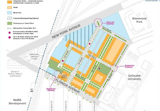
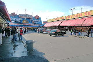
Just around the corner from the ongoing revitalization effort that is NoMa, the Office of Planning (OP) is setting its sights on a similarly minded redevelopment initiative: transforming DC’s wholesaler haven, the Florida Avenue Market, into a “vibrant, mixed-use neighborhood that protects the look and feel of the historic retail markets” while also bring new residential, retail and office projects to the Northeast site.

With the aid of CORE Architecture and Design, EHT Traceries, Inc. and Economic Research Associates, OP released their findings on just how to achieve that seemingly insurmountable task (the surrounding area includes two of the District’s most notorious neighborhoods: Trinidad and Ivy City) late last month in the Florida Avenue Market Small Area Plan. The report details an impressive list of obstacles in the way of redevelopment – even for a city with as many impressive redevelopment challenges as Washington.

Though the crime rate in the surrounding communities goes unmentioned, here’s what OP sees as its primary concerns. Firstly, current zoning statutes prohibit residential development in the industrial zone - a problem that two nearby developments, the Washington Gateway and the Gateway Market and Residences, have been able to circumvent through the PUD process. Secondly, the Market area is comprised of 120 lots with 68 different owners – a ratio that will make acquisition by the city a costly, confusing and time consuming proposition. Lastly, of those lots, many are, in the words of OP, “underdeveloped” or vacant, which gives potential developers little or nothing to work with.

However, OP hopes to relieve that burden somewhat with their framework for potential redevelopment. Taking into account the site’s historic significance (the Center Market first opened in 1802; the flagship Union Terminal Market in 1928), current conditions and infrastructure, current economic and real estate analyses, and community input – “achieved through a series of community planning sessions, property ownership workshops, and through an Advisory Committee” that included City Councilmembers Tommy Wells and Harry Thomas, Jr., the ANCs 5 and 6, Gallaudet University, and Apollo Development – OP has arrived at a preferred mix of commercial and residential uses for the market area (pictured). In an ideal scenario, the Florida Avenue Market will become a new destination by linking NoMa, the New York/Florida Avenue Metro and the neighboring Gallaudet campus into cohesive, walkable and, yes, friendly, whole.

To that effect, the plan outlines extensive overhauls for each prime thoroughfare in the Market area - including the to-be-reopened 3rd Street – with rehabilitated historic buildings, public parks, new signage and linkage to the Metropolitan Branch Trail. All of this would be done according to “Deaf Design Space principles,” in order to make the area welcoming for Gallaudet’s 1500 strong student population. Sound like a challenge? It will be, but OP hopes to relieve some of the burden from developers by encouraging a 20% tax credit towards the renovation of historic buildings on site.

Presumably to fill in the many remaining question marks (and gear up for an oncoming onslaught of RFPs), OP will be hosting a “Mayoral Hearing” concerning the Market on May 18, 2009 from 6:30 PM - 8:30 PM at Gallaudet’s Merrill Learning Center Building . The meeting will be open to the public - with questions and comments on the Area Plan encouraged. OP’s two-part plan for the Market can be read in its entirety here.

Wednesday, April 15, 2009

Anacostia to Get its Own Boathouse Row

2 comments
With the District-led attempt to bring development to Southeast Washington DC's Poplar Point now stalled for the foreseeable future, both the Office of the Deputy Mayor for Planning and Economic Development (ODMPED) and the Office of Planning (OP) have now turned their collective bureaucratic eye across the Anacostia River and towards a section called Boathouse Row.

In the spring of 2008, the District agencies assembled a team to consider options for the riverfront, which has now gone public with a Planning Study for the stretch of land that runs along M and Water Streets, SE on the Anacostia’s west bank. As is, the site - largely overlooked by development next door at the Capitol Riverfront - is currently home to half-a-dozen maritime operations, including a cadre of "yacht clubs," the former Anacostia Marina, and installations servicing the DC Department of Public Works, the US Army Corps of Engineers and the DC Water and Sewer Authority. Rehoboth Beach it won't be, but for the local government, redevelopment at Boathouse Row represents a shot at making the Anacostia River a recreational destination again for the first time in half a century.

The outcome of the study hinges on the proposed dredging of the polluted and endangered river – a procedure that has yet to be budgeted or approved by the DC government. As such, the team presented two concepts for the site – one contingent on a clean-up, the other not.

Concept I, which assumes dredging will in fact take place, would see the Anacostia Community Boathouse Association expand its location underneath the 11th Street Bridge, while the other boat clubs along the riverbank will be permitted to build-out “either perpendicular or parallel to the shore.” The team envisions three open “community spaces” at intermittent points along the river with amenities like canteens and bike rental kiosks, in addition to a revitalized and expanded Anacostia Marina for motorized watercraft.

Concept II, “a response to the possibility that dredging the Anacostia River will not take place,” assumes that the river will remain impenetrable to boats of any significant size. The locations of the various yacht clubs would be reconfigured, while the Sewer Authority’s work station would be relocated off-site in order to provide for a “continuous waterfront edge.” This plan too calls for three large community spaces along the river, but improvements to the Anacostia Marina would be significantly downsized and it would be outfitted to service only non-motorized boats.

No matter which route the District takes at Boathouse Row, neither will be realized soon. According to the report, “Several District infrastructure projects will need to be completed before improvements to Boathouse Row can be implemented.” That includes renovations to the 11th Street Bridge, completion of the Anacostia Waterfront Initiative’s Riverwalk Trail and the possible relocation of the Federal Channel. At present they’re projecting those procedures to run until at least 2014, with implementation of either concept expected to be complete by 2020.

It should also be noted that control of Boathouse Row currently sits with the National Park Service; a formal transfer of the land to District government is planned for later this year. The entire Planning Study can be read in its entirety at the ODMPED homepage. homes are for sale in washington dc.

Monday, February 09, 2009

Insider Interview: Sean O'Donnell and Matthew Bell of Ehrenkrantz Eckstut & Kuhn Architects

0 comments
While architectural firms around the region quietly rightsize their workforce, international architects Ehrenkrantz Eckstut & Kuhn have announced three new projects with the District of Columbia, including a study for the cloverleaf at North Capital Street, a master plan for Northwest’s Mount Vernon Square neighborhood and the modernization of Glover Park’s Benjamin Stoddert Elementary. Not a bad start to 2009. Oh, and they're designing the PN Hoffman-led development of the Southwest Waterfront. Enough to keep them busy for weeks. Two principals with the firm, Sean O’Donnell and Matthew Bell, took some time to sit down with DCmud.

Tell us a little about the firm and your approach to architecture.

SO: There are 35 people in this location. We also have offices in New York, Los Angeles and Shanghai. We’re an international practice and this just happens to be one of our offices. Our offices all collaborate on projects, so our work and expertise flow back and forth. I’ve worked in all four of the offices, for example, and that’s quite common. Our skill set, I think, is a little different than some of the other practices here in town. We do a lot of very large scale master planning, such as the Southwest Waterfront and on other things like Reservation 13 or Inner Harbor East. We’ve done a lot of waterfront planning across the country. That’s part of the large scale vision of the practice and we take that with us into any project, of any scale. Even when we’re doing building scale projects, like the many schools we’ve done here in the District, there’s always a larger vision of how it engages its context and the community.

MB: In DC, we’ve done the School without Walls, the George Washington University master plan, the Georgia Avenue master plan from just north of Howard, and we helped with the Wisconsin Avenue plan. We did the U Street plan and the Reservation 13 master plan that’s in development. We did the baseball stadium site study that located the stadium down where it was built. We worked with Mayor’s office on Great Streets. Right now, we’re doing the Deanwood Recreation Center over in Northeast.

You are the master planner for the Southwest Waterfront project, possibly the most prominent single development in the city. Tell us how you were chosen for that project.

MB: There was an international selection process between the Office of Planning and the developer who was eventually selected, Hoffman-Streuver. I don’t know who else had submitted, but our partner, Stan Eckstut – who was one of the founders of the firm – has made a living doing great waterfronts. He did the waterfront in Long Beach, California, the waterfront in Los Angeles and the promenade in Battery Park. We’ve all learned a lot from Stan about how to approach that kind of project.

What can we expect from the Southwest Waterfront? The only other true counterpart it has at present is the Georgetown Waterfront. What will the comparisons be once it’s completed?

SO: Well, one thing we learned from Stan about waterfronts is how important the water actually is. You need to have a plan for the water too, and not just focus on the land side of things.

MB: What happens on the water totally influences the rest of the project. I think the general feeling is DC doesn’t have, outside of the Washington Harbor, a place where the city comes right to the water. If you think about, most of Georgetown pulls back and places like the Navy Yard never really went right to the water and, for years, were industrial. And, of course, the Anacostia is silted up and never became a great port. If you go back and look at the L’Enfant plan for the city, people were originally going to come by water and then travel by canals, so it was going to be a waterfront city. It never really happened that way and the idea is to finally bring the city to the water with people living there, working there, hotels, retail, restaurants and all different kinds of activity.

How do you go about integrating those original L’Enfant designs into your plans for a modern development?

MB: We base all of our work on what works in other places, so we spend a lot of time looking at precedents. We feel very strongly that great places are made by looking at other places, taking those ideas and using them as a basis for new ideas. I don’t think necessarily we’re trying to reinvent; rather, we’re taking the best of what you have at other waterfronts across the world and trying to make something that’s unique for DC. The L’Enfant plan is one aspect of that, but there are other ideas and other places as well. There’s an idea to connect to the Mall along 9th Street, there’s an idea to make Maine Avenue a vibrant place with active waterfront uses that ties in the existing fish market in a creative way.

EE&K designed the Inner Harbor East project in Baltimore. How would you rate the success of that project, and how would you do it differently if you were to start over again?

MB: What we tried to do there was to design a network of public places. We realized that the market might change, the buildings might change, but if you have strong idea about the kind of places you’re trying to make and you preserve those in the plan, you’ll get a general network of public spaces all along the waterfront. I think a lot of what we’ve learned over the years is that though market forces do have their effect on cities, but if you have a strong idea about place, those things will work out.

SO: When you think about the timeframe that it takes to implement these kinds of plans, the dynamic changes throughout the course of it. Battery Park City has been in the marking for 25, 30 years and we’re actually doing the last two buildings right now to complete the plan. It’s taken a generation.

MB: We try to take the long view. Stan’s been working on Battery Park City for 25 years. We designed the Hill East Waterfront in 2001 and here we are in 2009. Lots of time these master plans do take a long time for their complete realization, and we understand that.

SO: Part of our approach, though, is that since these things can take time, the first phase feels intact and complete. So while there may be 60-acres of development to go, that initial project feels like it’s not a construction site. That’s critical.

The District recently selected EE&K to design a “North Capitol Gateway,” but the details were left a little vague. Can you tell us what shape that project will take?

MB: We’re working now for the Office of Planning, looking at the cloverleaf at North Capitol and Irving. They’ve asked us to imagine different options that are more pedestrian friendly, less highway-like than what’s there now and that work better with the surrounding property owners and uses – like the hospital, Catholic University and the redevelopment of the Armed Forces Retirement Home. The NCPC master plan identifies this as a place that could have more memorials and things, so we’re trying to look at this a new gateway to the monumental core. It could be much more like a parkway, not unlike Rock Creek Park. One of the challenges is that there is a lot of green space in that part of town, but very little of it is successful. They’re seeing this as potential catalyst project, but we’re just really starting it now.

You’ve both worked on projects all over the world, giving perspective about the District's development process. How would you rate the process, especially with regard to the height limit and other procedural differences that set it apart from other parts of the country.

MB: There are plenty of cities that have tall buildings that are really ugly. If the restriction was such an economic deterrent, then there wouldn’t be developers in this town.

SO: We do work across the country, but both Matt and I live in the District. Every time I come back, I always enjoy returning to Washington. And I think the process here is really quite good. It can be complicated, but, having worked in other jurisdictions, there’s a level of professionalism here with the CFA, NCPC and Office of Planning. Their interests are the same as ours; we’re both after a very quality urban environment. The public process here can actually elevate the results.

MB: I agree. Compared to other places, there are a lot of very smart people working at the regulatory agencies here. And with all the specific experiences we’ve moving projects through the regulatory process here, they only seem to get better. I can’t really sit here and say, “This is bad” or “that’s bad.” Sometimes, it’s lengthy, but it is anywhere. Once you set that aside, their concerns are always justified. It’s that kind of balance between the imperatives of the private development world and the regulatory bodies that results in a better product. Most of these bodies recognize that good development is good, and they know that there are certain kinds of development they don’t want to do. We don’t want to do them either – drive-ins, strip malls, and that kind of thing. We share the same objectives. DC is a good place to practice.

Saturday, February 07, 2009

EE&K Tapped for Three District Projects

0 comments
Ehrenkrantz Eckstut & Kuhn Architects have been awarded three multimillion dollar contracts in the District of Columbia, according to a statement released by the architectural firm. The first entails designs for a new gateway to the city’s “monumental core,” while the remaining two involve the creation of a master plan for Northwest’s Mount Vernon Square neighborhood and the modernization of Glover Park’s Benjamin Stoddert Elementary, respectively.

The first project reaffirms the city’s intent to install a definitive entrance to Washington’s tourist attractions. According to the press release issued by the firm, “[t]he study will be focused on North Capitol Street from Michigan Avenue to Hawaii Avenue, NE, and Irving Street/Michigan Avenue from First Street NW. The gateway would bring a sense of place to the adjacent neighborhoods and improved balance between the pedestrian focus of those neighborhoods and vehicular traffic flow and provide the initial design ideas for replacing an unsightly highway-style interchange with a more pedestrian-oriented design.” There’s no word, however, on when the first conceptual designs might begin to surface.

Meanwhile, in cooperation with the District’s Office of Planning and Department of Transportation, EE&K will be implementing infrastructural flourishes throughout the Mount Vernon Square with the hope of artfully integrating the borders between the Square, the recently opened Convention Center, and the historic Shaw neighborhood. EE&K has previously worked in a similar capacity with both the District’s Hill East neighborhood and Baltimore’s Inner Harbor.

For their third and final District-sponsored project of the New Year, EE&K has been paired with Setty & Associates and KLTH Engineers to "modernize and expand" Ward 3’s 77-year-old Benjamin Stoddert Elementary School. The long overcrowded school will receive a new gym, cafeteria and media center under the guidance of the development team, while the school’s 6.5 acre plot has also been earmarked as the site of a new “intergenerational community center” by the Department of Parks and Recreation. EE&K principal Sean O’Donnell will be overseeing the school renovation and has assured the community that the firm has a wealth of experience when it comes to “[creating] sustainable 21st century schools that are the center of their communities.” EE&K has previously supplied designs for other local educational institutions, such as the School without Walls and Washington University’s Foggy Bottom campus.

Tuesday, February 03, 2009

Awaiting the New Bruce Monroe

2 comments
Several District agencies are currently in the midst of coordinating plans for the demolition and subsequent reconstruction of the recently closed Bruce Monroe Elementary School. The 36-year-old educational facility and recreation center, located at 3012 Georgia Avenue NW, closed its’ doors this past June along with several other neglected DC public schools after years of making do with shrinking budgets, overcrowding and/or deteriorating conditions.

In a Request for Proposals issued by the Office of the Deputy Mayor for Planning and Economic Development (ODMPED) this past autumn, the 121,000 square foot lot will be repurposed with a new school and, in the words of the Office of Planning, "a mixed-use development project which [is being] developed to fund the new school." Though the Mayor's office has yet to announce a development team, DC Public SchoolsOffice of Public Facilities Management has been tasked with overseeing the school's development, while ODMPED and the DC Department of Small & Local Business Development share the responsibility of seeking a partner for the project’s mixed-use component.

ODMPED’s Communications Director, Sean Madigan, tells DCmud that there is no firm timeline for when the demolition may take place, but the Deputy Mayor Neil Albert’s office is currently in the process of securing the necessary paperwork in order to expedite the process once an announcement is made.

At present, the bulk of Bruce Monroe’s former student body and staff have been consolidated into nearby Park View Elementary at 3560 Warder Street NW - which itself will be closed once school bells start ringing at Bruce Monroe Elementary’s newest incarnation. According to ODMPED, Ward 1’s newest old school is currently scheduled to be “open in time for the fall of 2011.”

Thursday, January 08, 2009

SW Waterfront Nets its First Casualty

6 comments
Hoffman Struever, fish market, wharf southwest, Eccles Rouse, DCJust weeks after the City Council's approval of a Land Disposition Agreement authorizing the Hoffman-Struever, LLC’s redevelopment of the Southwest Waterfront, progress, of a kind, is already being made. The first casualty Hoffman Struever, fish market, wharf southwest, Eccles Rouse, DC retail for leaseof the development process appears to be the Virgo Fish House – a staple restaurant of the famed Maine Avenue Fish Market. Shrimp cocktail enthusiasts shouldn’t fret, however; while the restaurant’s current quarters are scheduled to be demolished in tandem with another abandoned property at the site, the remainder of the Washington landmark at 1100 Maine Avenue, SW, will be safe for the foreseeable future. "The blue building, which formerly operated as a crab house [will be razed],” says Nina Albert, a Project Manager with the Office of the Deputy Mayor for Planning and Economic Development. “That blue building will be replaced with a temporary Fish Cleaning Building, and...the building that Virgo’s is currently operating out of will be demolished. The intent of these small moves is to keep the Fish Market in safe and operable condition until the redevelopment occurs.” That redevelopment by the Hoffman-Struever development team – which is officially comprised of comprised of PN Hoffman, Struever Bros., Eccles & Rouse, McCormack Baron Salazar, ER Bacon, Gotham, City Partners, Triden and the recently added Paramount Development – isn’t expected to begin anytime before 2011, but it’s also worth noting that the Maine Avenue Fish Market was also targeted by 2008’s National Capital Framework Plan. The Plan – drafted by the National Capital Planning Commission - seeks to reintegrate Maine Avenue into the fabric of daily life in the District by refurbishing the Market’s home at the Overlook and linking it with an extension of 10th Street, SW.


Washington DC retail development news

Tuesday, November 11, 2008

Tenley Wars III: The Council Strikes Back

8 comments
Protracted. Excruciating. Unnecessary. These are but a few words used to describe the ongoing battle being waged by local community groups opposed to the Office of the Deputy Mayor for Planning and Economic Development (ODMPED) and developer LCOR Inc.'s plans for a new Tenleytown-Friendship Heights Neighborhood Library and residential development. And yet the twisting story further intensifies since DC City Councilmembers Mary Cheh and Kwame Brown have stepped into the fray.

At issue is the construction of a new Tenley Library to replace its predecessor (closed 4 years ago), updates and additions to the over-enrolled and threadbare Janney Elementary school, and, in return for these improvements, permission for the developer to build a residential complex on the site. A win-win scenario about which no one seems happy. The newest chapter involves LCOR's latest proposal to extend the residential component onto the school's green space (an ingredient mysteriously pushed by the Deputy Mayor and seemingly favorable to no one), a move that spurred Janney's School Improvement Team (SIT) to revoke its conditional support of the three-tiered agreement. Remaining undecided is the pace of renovations to the school, which the District wasn't planning to get to until 2013 despite immediate needs, hence the SIT favoring a quicker fix by the developer.

With the school's support withdrawn in the already contentious battle, Councilmembers Cheh and Brown penned a letter to Mayor Fenty expressing their wish to see the project’s library component move forward, while insisting that LCOR’s residential development be sent back to the drawing board.

“We write to ask that you permit the Tenley Library to build now and separate it from any possible mixed-use, or public/private, development on the site,” read the statement's first paragraph. “As for the current LCOR proposal, we believe that it is fatally flawed,” begins another. Cheh and Brown propose a compromise that would allow the library to be constructed with structural supports in place to accommodate any future development above. Meanwhile, the residential component would be put on hold until a mutually agreeable design is produced. In conclusion, the letter asked for a response to their concerns by Friday, November, 7th.

The Letter hinges on LCOR's plans for the residential component, initially planned to sit on top of the library, then moved (by mysterious edict of a revised RFP) off the library and in place of the neighboring Janney soccer field. Now, two differing LCOR site plans (dated November 4th) put the apartments back on the library once again, but still encroaching on Janney green space. That in turn caused SIT to withdraw their support, as both proposals take up some of the green space now used by Janney, but add it back in behind the school, in place of the surface parking lot. According to Kirk Rankin of the Janney SIT, the SIT is opposed to any plan that would require Janney to cede any of its green space for the development.

Still with us? Good, because further complicating matters is the timing, and everyone agrees the quicker the better. And yet The Letter contemplates a two-year construction of the library, completion of which would be followed by a second construction project on the same small site, a process that may yield an architecturally challenged, ever-dusty construction site.

Cheh was not amused by the Deputy Mayor's response, or lack thereof, to The Letter. “Immediately after [receiving our letter], the Deputy Mayor for Economic Development issued a statement saying they were going ahead with it. No one has ever explained to me, ‘With what are they going ahead?’” said Councilwoman Cheh, referring to the widespread confusion resulting from the repeated relocation of the residential units.

While ODMPED would not respond to DCMud's inquiries regarding the matter, an LCOR representative did comment on the council's qualms and the impact that residential development will have on the school zone. “We’re going ahead with it and [ODMPED] is going ahead, too,” said Timothy D. Smith, Senior Vice President of LCOR. “The two [library and residential] are combined. It’s one building with a very prominent location along the street that reads ‘Library’ when you’re riding along Wisconsin Avenue…it’s probably the best way to use the land, rather than build separate apartment buildings.”

"We've been working on this steadily and people make comments in the meantime," he continued. "We were working down Mary Cheh's list of things that she wants to see accomplished when the letter was written...We have been meeting with citizens groups and modifying our plan. We do hope to gain support back from Mary."

Councilwoman Cheh, however, was not quite as optimistic with respect to the library’s future: “If they surplus property, that requires council approval. If the ward councilmember doesn’t approve of the action, I doubt very much that my colleagues would approve of it over my opposition.”

Meanwhile, a standalone library has been funded and approved and could, with Council okay, start construction relatively soon. We'll be waiting to see who blinks. Stay tuned for Episode IV: Revenge of the SIT.
 

DCmud - The Urban Real Estate Digest of Washington DC Copyright © 2008 Black Brown Pop Template by Ipiet's Blogger Template