Showing posts with label NCPC. Show all posts

Friday, May 07, 2010

Vets Medical Center Expansion Gets Initial OK

3 comments
Thursday, the Veterans Affairs Medical Center master plan moved one step closer to making the proposed changes for the 350-acre campus. The National Capital Planning Commission (NCPC) approved the plan, which proposes to expand and modernize the existing 900,000 s.f. medical center with 818,000 gross s.f. of additional space, creating a massive 1.7 million gross s.f. development. The expansion, which is split into four phases, will take place over the course of 20 years and is set to finish in 2030.

According to the NCPC, "the proposed development will increase inpatient and outpatient areas, add a new long-term living facility space, add medical research space, consolidate administrative functions, and improve site utilities." The VA's proposal will make better use of the current surface parking lots by either building new facilities or converting them to green space. Employees, patients and visitors will rely on two new structured parking garages. The north garage will come online during the third phase; NCPC advised the VA to closely monitor parking use and demand for better planning of the matter. The plan will actually reduce the parking ratio to one space for every four people, reducing the number of staff spaces by almost 300. Additionally, the plan increases the amount of open green space on the campus from 19% to 33% of the total acres.

The NCPC stressed the importance of addressing the urban context, accordingly the plan places new structures nearer to the edges of the property. The design also includes extensive planting of trees and new shrubbery along North Capitol Street to provide a buffer between the massing of the new medical buildings and traffic.

The VA also has a transportation plan to increase the accessibility for bus, Metro and pedestrian commuters. The VA team has discussed transportation with the nearby Washington Hospital Center and proposes a new "transit center" along 1st Street. The new center would change the bus circulation pattern, reducing trip times. It will also include either a pedestrian bridge or "enhanced crosswalk" to make the intersection safer.

A mere 20% of the project will be built in the first three phases and some of the plans already have funding, meaning they could begin over the course of the the next five years. The other 80% will take place in the fourth phase, which is scheduled to wrap up in 2030.

Washington, DC real estate development news

Wednesday, May 05, 2010

Cohen Proposes Southeast Development

4 comments
Though much has been made of the development plans in the Southeast ballpark area, another part of Near Southeast is finally getting some attention, not without drama. This week, the National Capital Planning Commission (NCPC) will review the Cohen Companies' plans to permanently close several unimproved streets that fall within the original L'Enfant city and are technically federal property, but that are now effectively segregated from all other life forms by the Southwest Expressway and Anacostia River. The intersection of 14th Street, M Street and Virginia Avenue in SE could get the addition of 815,000 s.f. of hotel, retail, office and commercial space, if the District and the Developer manage to jump some technical hurdles before a June 1, 2010 deadline. A little background: MIF Realty had a 99-year assignment agreement (lease) with the District for the Southwest Gangplank Marina. In June 1999, the Cohen Companies, under the name CASCO Marina LLC, sought to take over the leasehold from MIF, a contract between the two companies required that the lease transfer take place prior to November 22, 1999 or the contract would be automatically terminated. Enter the District. The District's Redevelopment Land Agency (RLA) stepped into the lease transfer, requesting several hearings and ultimately ruling that MIF was in default on the property for not having properly addressed damage and disposed of insurance proceeds. RLA would overlook the default in exchange for a re-negotiated lease for the marina upon the transfer to CASCO. The RLA officially handed down this decision on November 22, 1999 at which point MIF contested the default claims and simultaneously allowed the contract between CASCO and MIF to end. CASCO proceeded to sue the District for interference in the transaction and for $25 million in punitive damages. 

 After several suits and appeals, the District and CASCO eventually entered into a settlement agreement. The District will transfer the Southeast property, valued at $8 million, to the developers and ensure District support of the street closings and necessary zoning changes to allow a development with a 6.0 floor to area ratio density. In exchange for the land and support, the Cohen Companies will release its claim to a leasehold to the Gangplank Marina. The whole process has a ticking clock; if the land exchange, zoning and street closure approvals are not finalized by the June 1, 2010 deadline referenced above, then the Cohen Companies can withdraw from the agreement and could once again pursue a lawsuit against the District over the Southwest property and related punitive damages. The District Council in March approved the land transfer and density elements. The bill was then signed by the Mayor in April and will receive Congressional review. According to the NCPC staff report, the agreement should be law by May 27, 2010. NCPC will review the matter Thursday and submit its opinion to the Council for consideration, the Council will vote on the street closures bill this month. The street closures bill would exempt the developers from several requirements, such as paying rent on the closed street and from having to provide affordable housing to offset the increase in commercial space. NCPC's Staff Report finds fault with several elements of the plan, in both the agreement between the District and the developer and with the actual design. NCPC staff notes that the streets in question are part of the original L'Enfant Plan, and therefore owned by the federal government. But NCPC cannot actually administer the necessary bureaucratic smack down to resolve the conflict between District and the feds about the rights to transfer titles. NCPC's Staff Report also notes that the plan for bridges connecting the proposed buildings would block viewsheds (see image at left for the lovely view from the property line). Now, that's a familiar complaint...think streetcars. The staff recommended an approval of the initial design, but suggest the obstructing elements be kindly removed. The NCPC will take up the issue this Thursday. 
  Update: To clarify, the NCPC's stance on the viewsheds and vistas within the L'Enfant plan reflect the opinion of the District's own Historic Preservation Review Board (HPRB). In January the HPRB recommended that "any encroachment on L'Enfant views and vistas be completely avoided or minimized to the maximum extent feasible." 

Washington, DC real estate development news

Thursday, April 29, 2010

NCPC To Hold Web Forum on Park Plan

4 comments
On Thursday at 1pm, DCMud will host a live web dialogue with the National Capital Planning Commission (NCPC) to discuss CapitalSpace, a partnership between the District, National Park Service, and NCPC to improve access to and the quality of DC's many local parks.

After a public comment period, NCPC adopted the CapitalSpace final plan on April 1st, and Commission staff is now working to implement the recommendations. NCPC's web panelist will be Julia Koster, Director of the Office of Intergovernmental Affairs for NCPC and former development coordinator for the Governor's Office of Smart Growth in Maryland. DC's park system, uniquely challenged by overlapping governing bodies and high tourist traffic, not to mention neglect, now has plans for the first revamp in 40 years spearheaded by NCPC, the planning body for the federal region that oversees development on or near federal land and coordinates the area's capital improvement plan.

CapitalSpace sets out "six big ideas" that, in short, seek to better connect the parks with each other by "weaving a greenway" through the neighborhoods from park to park, improve the parks, and connect the parks with DC's underutilized rivers.

1. Linking the Fort Circle Parks: Creating a walkable green space with historic significance by connecting the series of defensive forts built to encircle DC during the Civil War - a function of the McMillan Commission of 1901 that set out to establish "Fort Drive," a green beltway around downtown DC. Only small sections of the green roadway were ever established.

2. Enhancing Center City Parks: With 30 percent of the city’s future housing growth and 70 percent of job growth likely to occur downtown and along the Anacostia River, downtown parks add vibrancy, but place high demand for active uses.

3. Transforming Small Parks: Of the city's parks, 67% are small - less than one acre. NCPC plans to refurbish small spaces greater recreation and for "cultural and historic commemoration."

4. Enhancing Urban Natural Area: On top of providing recreational areas, the parks serve an ecological function as well - providing "pathways for wildlife" to move around the city.

5. Improving Playfields: DC's various athletic fields, of which there are more than 1,000 throughout DC, will be accorded "the highest level of planning and upkeep." Designs include better lighting, synthetic turf, and an online system of registering and reserving fields.

6. Improving Public School Yards: A plan to improve the 30% of the District's playgrounds, fields and courts that are run by the DC Public Schools (DCPS).

Factors that influence regeneration of the parks: Some 68% of parkland in DC is controlled by the National Park Service; 35% of DC children between 10 and 17 are obese; DC has 12.9 acres of park per 1000 residents (7617 acres) - one of the highest in the nation; DC has .217 athletic fields per 1,000 residents - one of the lowest ratios on the east coast; the District Department of Transportation manages about 250 small parks in DC; Washington DC is expected to increase from in population from 600,000 to 700,000 by 2025.

Washington DC real estate development news

Friday, April 02, 2010

Reflecting Change on the Mall

0 comments
On Thursday, the National Capital Planning Commission (NCPC) approved changes to the reflecting pool area of the National Mall. Modifications to the celebrated vista will include a fresh source of water, revitalized pedestrian walkways and, of course, increased security measures, though NCPC officials assure us the new security features will visually improve the site.

In what NCPC staff report called "a comprehensive rehabilitation," the Commission voted to approve the National Park Service (NPS) plan to upgrade the Elm Walks by repaving the walkway and adding better lighting and seating. On the immediate north and south of the reflecting pool NPS will add pavers to replace the dirt paths. A less obvious upgrade will be the water source that fills the reflecting pool, which will switch from potable (treated) drinking water to tapping the Tidal Basin. In the works is a plan to dig a trench and lay a plumbing system that will pump water from the Tidal Basin directly into the reflecting pool.

According to David Levy, Director of Urban Design and Plan Review at NCPC, this feature and the repair of leaks in the pool will result in a cleaner, "more sustainable" and less wasteful water supply. Levy says the same changes will eventually be applied to Constitution Gardens to the immediate north.

This being DC, enhanced security is also on order. But in a welcome change, NPS will use natural boundaries as entry barriers to the Lincoln Memorial, lowering the floor of the reflecting pool to create a natural barrier for crazies driving land vehicles approaching from the east. "The most brilliant part of the whole design, is that they will use the edge of the reflecting pool as part of the barrier...This is the kind of innovate security that NCPC encourages, you get increased security without impacting public space," says Levy. Unless of course a terrorist manages to obtain a DC Ducks vehicle, but odds of that are pretty low. Once the changes are in place, NPS will remove some of the protective bollards and all of the temporary planters now on the site for an overall aesthetic improvement.

Washington DC real estate development news

Thursday, February 25, 2010

The Future of Washington DC Transportation

18 comments
One year after Gabe Klein took the helm at the District Department of Transportation (DDOT), the District agency has a brand new website, an aggressive two-year plan and a progressive approach to transportation. Yesterday, DDOT Director Klein invited several transportation bloggers to discuss the agency's progress during his first year, and plans going forward. By 2012 DDOT aims to more than double the 2009 bicycle road share, add 250 car-share vehicles, increase Circulator ridership by 47 percent, add six more "performance" parking districts and have 2.75 miles of operating streetcar lines. Yes, he went there: operating streetcars.

Klein described an agency embracing a culture shift, one that focuses on sustainability, safety and open communication. A new website, along with DDOT's social networking presence, are part of it's outreach to inform DC residents of the agency's services down to online plans about what DDOT has planned for their neighborhood and commute.

The DDOT Director is optimistic and confident that DC will resolve issues facing overhead wires for the planned 37 miles of streetcars through a combination of technology and, of course, compromise with transportation's other stakeholders - the National Capital Planning Commission, the Capitol Hill Restoration Society and the Committee of 100, among others.

Klein says the open dialogue has narrowed the wire issue to the North-South "viewshed" of the Capitol. Klein said he was determined to make streetcars happen and eliminate unnecessary overhead wires. At the same time, he's asking streetcar opponents to rethink the boundaries for overhead wires and to maybe allow them along areas of H Street to Benning Road.

There's also the matter of disguising wires. Klein said he took a trip with several BID directors and Marcel Acosta, Executive Director of NCPC, to see the streetcars in Portland, Oregon, which Klein said fit seamlessly into the transportation flow, with wires hidden by a canopy of trees. Klein joked that he even has a photo of Acosta smiling with an overhead wire dangling in the background.

On the technology side, Klein said he is working with United Streetcar, maker of the first American streetcar manufactured in the U.S. in 50 years, to develop hybrid solutions for power. Right now the cars can travel up to 1/4 mile just on battery power, but Klein hopes to get that number up to 1 mile by working with the company to developer a lithium ion battery. Klein is applying for federal funding to pay for the new batteries, and anticipates, with rapid changes in battery technology, that the cars could eventually run up to 2 miles on battery power alone. Like a Prius, with better brakes. Announcements about the streetcar project timing should come in the next few months.

Beyond the streetcar, Klein is seeking innovative solutions at every level of the agency. A Maintenance and Operations contract will be going out to bid soon, in which DDOT will ask for creative solutions that address the agency's needs. "Free consulting" from the private sector, said Klein.

Then there are changes coming to parking meters in pilot programs throughout the city; new solar-powered meters allow payment by coins or by credit card, "so people don't carry 16 quarters for two hours" said Klein. Since their inception, 52% of patrons started using credit cards, and in the study area DDOT has seen a 30% increase in parking revenue. Klein said of the pilot, "revenues are up, people seem to love it" but that he was not ready to say it was a definite success until he knew more about the machines' reliability. Another parking change is the pay-for-performance areas - which DDOT hopes to increase to eight by 2012 - where pricing for parking is based on demand. Klein admitted that testing this out in the ballpark district might not have been the best decision, but that the agency is expanding the concept to new areas to continue to test its effectiveness.

The new website is a good resource for residents to maneuver the various responsibilities of DDOT and to learn how to maneuver the streets of DC in ever-expanding ways. If DDOT gets its way, District residents in 2012 will have a markedly different transportation scene.

Washington DC real estate development news

Friday, January 08, 2010

Mark Center Drama in Alexandria

8 comments
Mark Center Alexandria Virginia commercial real estateMass murder, national security, terrorism: the usual stuff of National Capital Planning Commission (NCPC) meetings. Yesterday's review of the Washington Headquarters Services (WHS) at Mark Center, part of the Base Realignment and Closure (BRAC) project had all sorts of unexpected drama. The rare colorful discussion included one Commissioner who cited 9/11 as the reason for his disregard for community complaints about security measures, another sardonically suggested the Army valued employees over citizens, and a neighbor who loudly drew a picture of mass murder in the cul-de-sacs of Alexandria because of the new Mark Center. Mark Center real estate, AlexandriaThe two-hour NCPC soap opera belied the stringent federally-mandated design standards for the new behemoth, which leave few design elements up for debate. The 1.7 million s.f. building, developed by Duke Realty, will sit on 16 acres of land located west of Seminary Road and I-395 in Alexandria. Duke is working with project architects HKS and WBA, Clark Construction, as well as the Army Corps of Engineers and the City of Alexandria. The two office towers are 15 and 17 stories, connecting on their first 10 floors, and will house 6,400 DOD personnel. The exteriors will feature materials that meet federally mandated security standards including blast-resistant glass and preventative measures against "progressive collapse." Even with the limited flexibility for design, the Army Corps of Engineers worked closely with the City of Alexandria to accommodate concerns raised about the size and appearance of the buildings - with space for 29,000 employees it will be one of northern Virginia's largest - which will be highly visible from the surrounding community. Updated plans include architectural refinements such as more noticeable curvature on the rooftops and an area for a public art display at the North Parking Garage, though the City remains less than thrilled with the overall design. Army corps of engineers, alexandria virginia, commercial real estateThe planned remote inspection facility (RIF) was the reason for all the shouting and name calling at the NCPC meeting. The facility, which allows for dog inspection of vehicles prior to entering the main campus, will be located in a "secure area of the east campus, over 610 feet away from the office towers," according to the NCPC staff report. 

From the beginning, the City requested this facility be located in an off site location, citing design concerns, traffic issues and worries over the safety of the community. Since the original request the Army has determined that the facility must be located on site, but has made efforts to add screening along adjoining Seminary Road to minimize its visual impact and has added a green roof to the facility. According to Peter Sholz, Senior VP of DC Operations for Duke Realty, the group has adjusted the design significantly, even adding blast-proof features to reassure the community. Sholz said about the overall design that it is "important to note that the government agreed to make some significant modifications in response to comments from the city and citizens." He added that modifications to the RIF and changes in the design such as adding a circular loop access road, pedestrian bricommercial real estate development
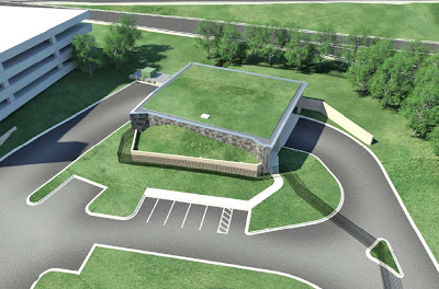
dge, and facade changes have increased the cost of the project to the government by between $15 and $18 million. Sholz said the final project costs are hard to estimate and it is "conceivable" that the added costs could be offset through various cost saving measures the group is taking. Despite the hubbub, the designs received NCPC approval, though not unanimous, and Sholz said the project is on schedule for completion in 20 months. On a technical note, the NCPC has an advisory role in reviewing federal projects in Northern Virginia in the "environs" if DC. Generally a project comes before the NCPC and does not begin construction until it receives final review with approval and recommendations. Mark Center is an odd exception to the processes and authorities of the NCPC in that the structure, despite lacking final approval, is already at advanced stages of construction in order to meet the BRAC federally mandated September 2011 timeline. 

David Levy, NCPC Director of Urban Design and Plan Review, said the Commission gave the project foundation approval in February, hence the construction, and that yesterday's meeting addressed the preliminary and final site and building plans. The design elements for the two towers debated at yesterday's meeting have not yet been constructed, though the developers hesitated to bend to the requests from Alexandria for further adjusted building designs; the steel for the structures has already been ordered. Sholz did say that the team spoke with their steel company just yesterday to see if there was a way to change the shape of the ordered product to meet the City's design requests. Sholz's continued efforts support Levy's assertion that the NCPC approval was in part an expression of the Commission's confidence the design issues could be worked out. 

Alexandria real estate and development news

Thursday, January 07, 2010

NCPC Approves Coast Guard Headquarters Design

3 comments
The new United States Coast Guard (USCG) headquarters planned for St. Elizabeths is now on track to begin construction as soon as February. The latest building designs, reviewed again and approved today by the by the National Capital Planning Commission (NCPC), include 1.175 million s.f. of space for upwards of 3,860 employees, addressing concerns raised by NCPC last January. Among those issues are increased traffic on Shepherd Highway, the massing of the USCG building and garage, and the location of the security perimeter with respect to the historic cemetery on the site of the first national mental health facility in the country. Last August GSA awarded the $435 million construction contract to Clark Construction, WDG Architecture and HOK , with concept designs by Perkins and Will. The Coast Guard campus will be the first of 3 phases at the historic hospital. Phase 2, the center building, will house the Department of Homeland Security (DHS) Secretary's office and other "senior" staff. Phase 3 will be largely new construction for storage and other warehouse facilities. retail real estate developmentThe Shepherd Highway issue is a sticky overlap of various federal authorities including the Federal Highway Administration, DHS, the General Services Administration, the National Park Service, the Department of Transportation and the Department of the Interior. DHS and GSA, along with the FHA, have determined that the highway is the best way for construction vehicles to access the West Campus to state construction. The National Park Service, which owns the land, objects because a portion would likely see permanent negative affects, but in the end the group agreed to keep exploring alternatives and continue on schedule for February construction. The Coast Guard HQ and parking garage will be built on a 118 ft slope visible from Haines Point and from Ronald Reagan Washington National Airport. Concerns about the appearance of the HQ as seen from around the city led to reduced massing and planning for additional vegetation. The new plan also adjusts the visibility of the garage which would originally have been five levels above-grade, two below, but now proposes an inversion - only two above-grade and five below, but with an expanded footprint. The garage will provide 1,973 parking spaces and will serve both the USCG and the Department of Homeland Security headquarters. The exterior of the garage on the northern facade now swaps an extended green wall system with the previous zinc-clad frame. Finally, though the original Master Plan created a security perimeter that excluded the historic cemetery, new plans include the cemetery within the security perimeter to restore it "to its place as an integral part of the West Campus." NCPC will hear more plans in March when they review Phase 1B. 

Washington DC commercial real estate news

Monday, December 07, 2009

Community Boycotts Groundbreaking for Affordable Housing

8 comments
When the development team for the $35 million Linda Joy and Kenneth Jay Pollin Memorial Community Development in northeast DC announced its groundbreaking scheduled for tomorrow, one thing they didn't count on was fierce opposition from the community. But they've gotten it, and then some. ANC7D organized a phone and email campaign that ultimately convinced Councilmembers Kwame Brown and, according to the ANC press release, Chairman Vincent Gray to boycott tomorrow's press conference and groundbreaking scheduled for 10:45 AM at Anacostia Avenue and Hayes Street, NE. Though Gray's office indicated the groundbreaking was still on his schedule. Pollin Memorial Community Development, LLC's planned development would bring 125 new affordable for sale and rental homes to northeast, a site which is a composite of property belonging to 3 government entities – the District of Columbia, the District of Columbia Housing Authority (DCHA), and the National Parks Service (NPS).

The Pollin project will replace one-for-one the 42 affordable rental units on site, known as Parkside Additions. The project was initially spearheaded by the late Abe Pollin and his Pollin Foundation, which courted the approval of all landowners back in 2006 and received approval for the project from NCPC last year. The current Parkside project was described by the National Capital Planning Commission (NCPC) as “functionally obsolete,” so no real loss there.

In July of 2009, ANC7D reviewed a loan request for $7.9 million submitted by the Pollin Foundation to the DCHCD (DC Housing and Community Development), however with only 30 days provided to submit a response, the ANC unanimously rejected the request, and continues to object. ANC7C04 Commissioner Sylvia Brown told DCMud in an email that the "Pollin team have not been transparent and open to communications." Of particular concern is the community benefits agreement and the plan for relocation and return for current Parkside tenants. According to Michael Price, spokesperson for Councilmember Kwame Brown, "the community is adamant that they are looking for a community benefits package and the Councilmember stands by them."

Terri Bolling, Spokesperson for Enterprise Community Investment, one of the development partners on the project,was unaware of the community's recent actions and plans to boycott the groundbreaking. She remarked "this is so strange" since community outreach "is what we do."

John Stranix, formerly of Clark Construction and now of Stranix Associates, is spearheading the construction effort using designs by Torti Gallas & Partners. The project aims to begin construction in early 2010 with the first units available in 2011.

Washington, DC real estate and development news.

Thursday, December 03, 2009

National Museum of African American History and Culture Design Process Crawling Along

10 comments
National Museum of African American History and Culture, Freelon Group, Morris Adjaye, Bond / Smith Group, national mall design competitionThe design for the future National Museum of African American History and Culture on the National Mall checked off its first of a series of reviews today, when the National Capital Planning Commission (NCPC) heard a presentation from the Smithsonian Institution and their chosen architect, Freelon Adjaye Bond/SmithGroup, about the plans for the building. National Museum of African American History and Culture, Freelon Group, Morris Adjaye, Bond / Smith Group, national mall design competitionThough commissioners praised the quality of the design, many expressed "serious concerns" about the current design's size and massing in relation to the Mall and the Washington Monument. The design process is scheduled to last approximately 3 years, with construction beginning in 2012. The 5 acres of land near the Washington Monument have been the subject of vociferous debate first with the National Park Service opposing its use for anything but the grassy space that exists today, then with 22 designs competing for the site and now with sundry federal and local agencies reviewing the merits of the design that won out over five other semi-finalists this past April. Bounded by Constitution Avenue, Madison Drive, 14th and 15th Streets NW, the site would be the terminus of the Smithsonian museums on the Constitution side of the mall, leading up to the Washington Monument. Washington DC, national mall design, commercial real estateThe current design is what the architect described as a pavilion, its base embracing the mound-like structure at the base of the neighboring "temple" buildings, which include the Museum of Natural History and the American History Museum. The building then opens inwards like a "front porch" to reflect a structure common in both traditional West African and southern African American cultures, according to the architect. The mass of the building is aligned with the Museum of Natural History and it is no higher than the American History Museum. NCPC commissioners generally commented favorably on the concept, especially praising the interior design of the building. However, one after another, members expressed concern that the building would diminish the impressiveness of the Washington Monument because, as one commissioner put it, the design "failed" to maintain "the integrity of the mall." Other commissioners mentioned that part of the design process involved the architects providing three alternative design concepts, a process which would "improve the final project." With the design far from finished, NCPC will hear from the team again in the spring of 2010.

Washington DC real estate development news

Thursday, November 19, 2009

The Joy of CSX: Capitol Hill Braces for Big Dig

10 comments
Thanks to expansion of the Panama Canal, Capitol Hill may be about to get its own Big Dig - a $174 million capital improvement project that will unearth the long-buried tunnel south of the Capitol Building to widen and deepen the antiquated freight line. For those that miss the obvious connection between Panama and DC, the $5 billion overhaul of the Big Ditch in Panama will now make it easier to ship cargo from Asia to the Gulf of Mexico, and from there into the midwest via rail lines, beating out formerly dominant west coast ports as the cheapest point of entry into the American interior. That is, if the rail lines can handle the increased cargo. Which brings us back to Capitol Hill.

In 2008, freight-hauling giant CSX, which owns the tracks that cross the Potomac and mole beneath the Capitol, launched its National Gateway project to improve the capacity of its rail lines, one of which happens to lie under Virgina Ave in Southeast DC. CSX plans to unearth the narrow tube from 2nd Street to 11th Street, beginning in 2011 and continuing for an estimated two to three years. Surely Bostonians are smirking sympathetically, but area residents and business are bracing for the worst.

According to officials from the company, the CSX rail lines that disect DC are some of the most congested on the line. According to the National Gateway website, a variety of factors lead to the decision to expand and renew the current freight system. Population growth, energy costs, and environmental factors will mean increased demand for freight. According to CSX, the current system of tracks, bridges and tunnels is outdated, hence the new plan to widen the tunnel and lower the tracks to allow for double-stacked trains, but in order to access the tunnels for construction, its Virginia Avenue ceiling will need to be removed.

In the late 1800's Congress authorized the B&O Railroad, now CSX, to build the tunnel and own the area below ground, while the federal government retained ownership of Virgina Avenue at grade. As with any major project in D.C., a spiderweb of authorities will have their say over the planned construction. According to National Capital Planning Commission (NCPC) Senior Planner David Zaidain, since CSX is applying for federal TIGER Grants to fund a portion of the project, the company will have to comply with the National Environmental Protection Act and the National Historic Preservation Act. NCPC has oversight because Virginia Avenue is technically federal land and is inside the L'Enfant City plan. NCPC will review the concept and give final approval to the public space effects of the project during and after construction. For good measure, the District Department of Transportation will be working with CSX to evaluate impact on traffic.

Assuming CSX obtains the federal grant money and jumps sufficiently through the various oversight hoops, residents on Capitol Hill can expect an extended period of construction and all its attendant pleasures. Among the joys of CSX: new traffic patterns - including temporary bridges connecting the numbered streets and diverted flows from Virginia onto G Street - construction noise, and the unmasked noise of trains running through the Capitol Riverfront neighborhood. For three years. Or more. And that's before planners start getting ideas about what other infrastructure goals could be accomplished while they're at it.

The project is particularly irksome to residents and businesses such as EYA's Capitol Quarters housing development. The new townhomes line the streets near Virginia Avenue and the proposed CSX plan is giving some future homeowners a (possibly justified) case of buyers' remorse. Some would-be buyers have backed off when they caught wind of the area's construction future. EYA Partner AJ Jackson had this to say about the Capitol Quarter community and CSX, "EYA has been in contact with CSX and will be working with the company as well as the District government to ensure that Capitol Quarter continues to be a great community if CSX’s National Gateway proposal goes forward. Our goal is to ensure that any proposal that’s considered includes the needs and concerns of the Capitol Quarter." Like moving massive amounts of freight from the gulf to the north and west. At least Hill residents can console themselves that this will save alot of fossil fuel consumption. And Bostonians will tell them that this too shall pass. But not soon.

Images from the NCPC and DDOT Freight Railroad Realignment Study.

Washington DC real estate news

Sunday, October 25, 2009

DC, Federal Agencies Hold Public Meeting to Improve DC Parks

1 comments
On Tuesday, the National Capital Planning Commission and partners will present the draft version of the joint CapitalSpace plan to the public. A joint initiative of NCPC, the National Park Service, and the District of Columbia Office of Planning, Capital Space is designed to create a "high-quality," unified park system in Washington DC by improving, connecting and expanding DC's park systems.

Members of the trio will give a presentation on the "six big ideas" for the District: Linking Fort Circle Parks by way of walking trails to serve as a green beltway around the District, improving public schoolyards, enhancing existing parks with more active uses, improving playfields (particularly increasing regulation sized playing fields), transforming small urban parks, and enhancing "urban natural areas" - supporting biodiversity while serving people. The plan is currently in a 60-day public comment period that concludes December 8th. The event will take place from 5:30 – 7:30 p.m. at the Martin Luther King Jr. Memorial Public Library.

Friday, September 18, 2009

11th Street Bridge Under Troubled Wires

7 comments
The 11th Street bridges that span the Anacostia in SE DC are one step closer to a transporation makeover, assuming government agencies can play nice. The National Capital Planning Commission (NCPC) recently reviewed the District Department of Transportation's (DDOT) design, which will replace the 40-year-old 11th Street bridges, improving traffic flow, connecting I-695 and I-295 and creating a pedestrian and bike-friendly addition to the I-295 bridge. The new bridges make accommodations for future street car use of the bridge, including features for (gasp) overhead wires. The bridges will get their makeover, but the street car may have to wait.


According to DDOT, the Southwest/Southeast Freeway (I-695) was originally planned as part of the "Inner Loop Freeway System," a highway system designed in the '50s and built in the '60s that was (thankfully) never fully completed. The portion at issue here was to connect the Inner Loop with the Anacostia Freeway (I-295/DC-295), a plan that was ultimately abandoned; to date motorists have no direct connection between the two highways north of the 11th street bridge complex. DDOT's plan suggests that this inconvenience leads to increased traffic on neighborhood streets like Martin Luther King Jr. Ave, Good Hope Road, Minnesota Ave and Pennsylvania Ave.

The current upstream bridge has four lanes headed north and the downstream bridge has four lanes headed south, for a total of eight lanes (we can add good); the new bridges will have a total of 12 lanes. The upstream bridge (I-695) will get an additional four lanes, or four in each direction, but two will be used as entrance and exit lanes. The downstream bridge (I-295) for local traffic will still have four lanes, two in each direction with the two outer lanes shared, in theory, by street cars and motor vehicles. The local traffic bridge will also include a 14 foot "shared use path" for pedestrians, runners and cyclists.

While the 11th Street Bridge plan does not directly provide for street cars, it does include the tracks, light posts, and overhead wires for the street cars that may eventually help bridge the chasm between the two sides of the Anacostia river. DDOT has been moving full speed ahead on the Anacostia street car program and is pretty excited about it (to anthropomorphize a bit), and weekly updates are now available online. The plan to install track lines in the new 11th street bridge is just another example of foresight by the transportation planning body.

But, DC being a jurisdictional hodge podge of government overlords, enter the turf battle. The NCPC Executive Director's recommendation stated that NCPC "does not support a street car system with overhead wires in the L'Enfant City" and encouraged DDOT "to pursue alternative propulsion technologies...that do not require overhead wires." The same issue was raised about the street car planned for the H Street corridor. The conflict is not going away any time soon.

If you paid attention to our NCPC crib notes last week, you'll remember that their authority over the historic Washington City means it will uphold federal law that prohibits overhead wires from obstructing view of landmarks.

DDOT and NCPC have clear mission statements and long-term plans, which often can work in unison to improve planning in the District. On this issue, however, it looks like we will see a showdown or at least some creative bargaining as the two agencies are pitted against one another in the what future generations will surely call the "Great Street Car Dilemma of L'Enfant City."

Friday, September 11, 2009

Obama Appoints New NCPC Chair

4 comments
Yesterday, President Obama appointed L. Preston Bryant Jr. as the new Chairman of the National Capital Planning Commission (NCPC). As Chairman, Bryant will lead the 12-member Commission charged with securing and enhancing the historical, cultural and natural resources of the capital region. NCPC also oversees federal construction projects, long-range planning efforts and planning policies. Bryant currently serves as Virginia's Secretary of Natural Resources.

The NCPC was established by Congress in 1924 (at that time it was known as the National Capital Park Commission). It is the central planning agency for sites on - or adjacent to - federal land in the National Capital Region, a jurisdiction that covers 2,500 square miles in DC, MD and VA. NCPC also provides an advisory role for the District government on certain land use decisions. NCPC focuses on four main principles:

Urban Design and Plan Review- NCPC reviews a wide range of plans and projects from memorials, museums and federal office buildings to communications towers and perimeter security projects. It also reviews District of Columbia public projects, proposed street and alley closings, and Zoning Commission actions, as well as private development in the Pennsylvania Avenue Historic District.

Comprehensive Planning- NCPC developed The Comprehensive Plan for the National Capital: Federal Elements, to guide decisions for long-term development on topics such as transportation, preservation and historic features, parks and open space, among others.

Signature Planning-
Long-term plans for the region including security concerns, transportation, and future memorials.

Federal Capital Improvements- NCPC helps set the federal government's development priorities by reviewing agency plans for capital improvements and advising Office of Management and Budget on which plans should move forward.

We hope you read this carefully; expect a quiz next week.

Saturday, September 05, 2009

Lincoln Memorial Improvements Get Favorable Review

2 comments
Much-needed changes are coming soon to the section of the National Mall surrounding the Lincoln Memorial, courtesy of the American Recovery and Reinvestment Act. Improvements will include sidewalks along the reflecting pool, new benches and ADA access but, alas, no changes to the reflecting pool itself.

On Thursday, the National Capital Planning Commission (NCPC) commented favorably on National Park Service (NPS) plans to rehabilitate the grounds on the east side of the Lincoln Memorial and adjacent areas in West Potomac Park, including the Reflecting Pool and Elm Walks. The latter, which extend past the World War II Memorial to 17th Street, will be refurbished with new lighting, benches, and trash receptacles.

Additionally the plan includes ADA accessible curved paths to connect Lincoln Memorial Circle with the Reflecting Pool. Other changes include a security-barrier, with NCPC recommending shorter walls than the 36-inch walls NPS had planned, to provide integrated seating without detracting from historic structures.

"They are pulling back the concrete and steel barriers and opening the vista, said NCPC Chairman John V. Cogbill, III. "The changes will allow for an unobstructed view between the Lincoln Memorial and the Washington Monument."

The project will also eventually address the source and quality of the stagnated water in the reflecting pool, but that portion will be submitted to NCPC at a later date.
 

DCmud - The Urban Real Estate Digest of Washington DC Copyright © 2008 Black Brown Pop Template by Ipiet's Blogger Template